xrspatial.bump.bump#
- xrspatial.bump.bump(width: int = None, height: int = None, count: int | None = None, height_func=None, spread: int = 1, *, agg: DataArray = None, name: str = 'bump') DataArray[source]#
Generate a simple bump map to simulate the appearance of land features.
Using a user-defined height function, determines at what elevation a specific bump height is acceptable. Bumps of number count are applied over the area width x height.
- Parameters:
width (int, optional) – Total width, in pixels, of the image. Not required when
aggis provided.height (int, optional) – Total height, in pixels, of the image. Not required when
aggis provided.count (int, optional) – Number of bumps to generate. When omitted, defaults to
min(w * h // 10, 10_000_000), wherewandhare the output raster width and height (taken fromaggwhen given).height_func (callable, optional) – Called once as
height_func(locations), wherelocationsis an(count, 2)array of integer(x, y)bump coordinates. It must return a 1D array ofcountbump heights. When omitted, every bump is given a height of 1.spread (int, default=1) – Number of pixels to spread on all sides.
agg (xarray.DataArray, optional) – Template raster whose shape, chunks, and backend (NumPy, CuPy, Dask, Dask+CuPy) determine the output type. When provided,
widthandheightare inferred fromagg.shape.name (str, default='bump') – Name of the output DataArray, for consistency with the other synthetic-terrain generators (
perlin,worley,generate_terrain).
- Returns:
bump_agg – 2D aggregate array of calculated bump heights.
- Return type:
xarray.DataArray
References
Examples
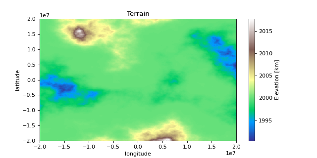
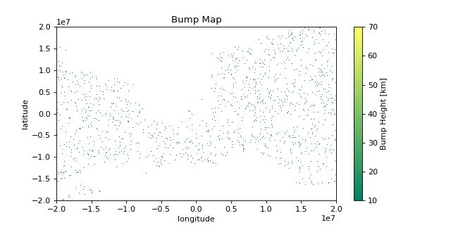
from functools import partial

import matplotlib.pyplot as plt
import numpy as np
import xarray as xr

from xrspatial import generate_terrain, bump

# Generate Example Terrain
W = 500
H = 300

template_terrain = xr.DataArray(np.zeros((H, W)))
x_range=(-20e6, 20e6)
y_range=(-20e6, 20e6)

terrain_agg = generate_terrain(
    template_terrain, x_range=x_range, y_range=y_range
)

# Edit Attributes
terrain_agg = terrain_agg.assign_attrs(
    {
        'Description': 'Example Terrain',
        'units': 'km',
        'Max Elevation': '4000',
    }
)

terrain_agg = terrain_agg.rename({'x': 'lon', 'y': 'lat'})
terrain_agg = terrain_agg.rename('Elevation')

# Create Height Function
def heights(locations, src, src_range, height = 20):
    num_bumps = locations.shape[0]
    out = np.zeros(num_bumps, dtype = np.uint16)
    for r in range(0, num_bumps):
        loc = locations[r]
        x = loc[0]
        y = loc[1]
        val = src[y, x]
        if val >= src_range[0] and val < src_range[1]:
            out[r] = height
    return out

# Create Bump Map Aggregate Array
bump_count = 10000
src = terrain_agg.data

# Short Bumps from z = 1000 to z = 1300
bump_agg = bump(width = W, height = H, count = bump_count,
                height_func = partial(heights, src = src,
                                    src_range = (1000, 1300),
                                    height = 5))

# Tall Bumps from z = 1300 to z = 1700
bump_agg += bump(width = W, height = H, count = bump_count // 2,
                height_func = partial(heights, src = src,
                                    src_range = (1300, 1700),
                                    height=20))

# Short Bumps from z = 1700 to z = 2000
bump_agg += bump(width = W, height = H, count = bump_count // 3,
                height_func = partial(heights, src = src,
                                    src_range = (1700, 2000),
                                    height=5))
# Edit Attributes
bump_agg = bump_agg.assign_attrs({'Description': 'Example Bump Map',
                                  'units': 'km'})

bump_agg = bump_agg.rename('Bump Height')

# Rename Coordinates
bump_agg = bump_agg.assign_coords({'x': terrain_agg.coords['lon'].data,
                                   'y': terrain_agg.coords['lat'].data})

# Remove zeros
bump_agg.data[bump_agg.data == 0] = np.nan

# Plot Terrain
terrain_agg.plot(cmap = 'terrain', aspect = 2, size = 4)
plt.title("Terrain")
plt.ylabel("latitude")
plt.xlabel("longitude")

# Plot Bump Map
bump_agg.plot(cmap = 'summer', aspect = 2, size = 4)
plt.title("Bump Map")
plt.ylabel("latitude")
plt.xlabel("longitude")
>>> print(terrain_agg[200:203, 200:202])
<xarray.DataArray 'Elevation' (lat: 3, lon: 2)>
array([[1264.02296597, 1261.947921  ],
       [1285.37105519, 1282.48079719],
       [1306.02339636, 1303.4069579 ]])
Coordinates:
* lon      (lon) float64 -3.96e+06 -3.88e+06
* lat      (lat) float64 6.733e+06 6.867e+06 7e+06
Attributes:
    res:            (80000.0, 133333.3333333333)
    Description:    Example Terrain
    units:          km
    Max Elevation:  4000
>>> print(bump_agg[200:205, 200:206])
<xarray.DataArray 'Bump Height' (y: 5, x: 6)>
array([[nan, nan, nan, nan,  5.,  5.],
       [nan, nan, nan, nan, nan,  5.],
       [nan, nan, nan, nan, nan, nan],
       [nan, nan, nan, nan, nan, nan],
       [nan, nan, nan, nan, nan, nan]])
Coordinates:
* x        (x) float64 -3.96e+06 -3.88e+06 -3.8e+06 ... -3.64e+06 -3.56e+06
* y        (y) float64 6.733e+06 6.867e+06 7e+06 7.133e+06 7.267e+06
Attributes:
    res:          1
    Description:  Example Bump Map
    units:        km